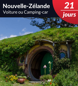
5
Please vote!
Your questions (51)
Add to my trip
Please contact us and we will help you to organize your trip! It's free and without commitment.
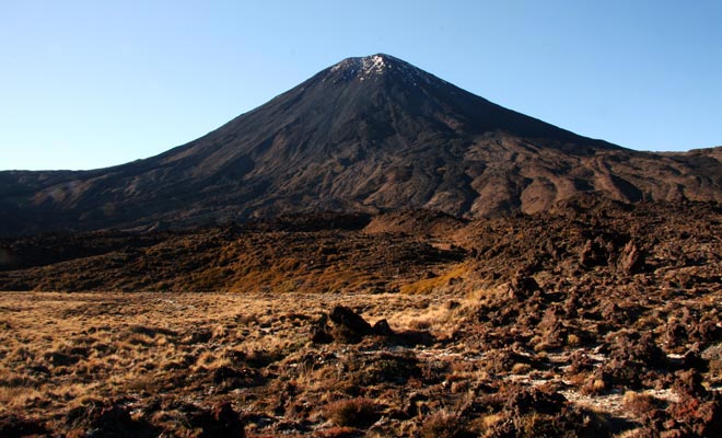
This trek alone justifies a trip to New Zealand.
If you come across visitors returning from a trip to New Zealand, there is a good chance they speak about the Tongariro Alpine Crossing trek. According to most travel guides (including Kiwipal), this is probably the most beautiful one-day trek in the world.
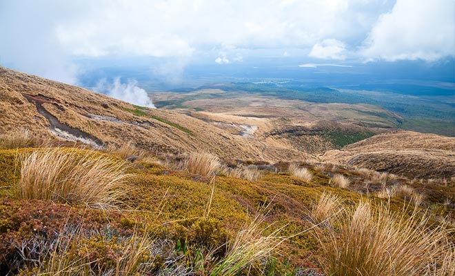
We will travel to to the heart of the North Island in the Tongariro. This national park is classified by UNESCO in two different categories. For the quality of its natural landscapes of course, but also for its cultural and spiritual heritage.
The trail crosses an alpine desert, circumvents volcanoes, descends into a crater, bypasses emeralds lakes and hot pools with geothermal activities and finally ends in a subtropical forest with streams.
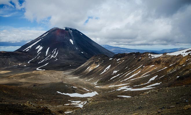
The fame of the Tongariro Crossing is based on the beauty and great variety of its landscapes. With White Island, this is the mecca of volcanic tourism in New Zealand.
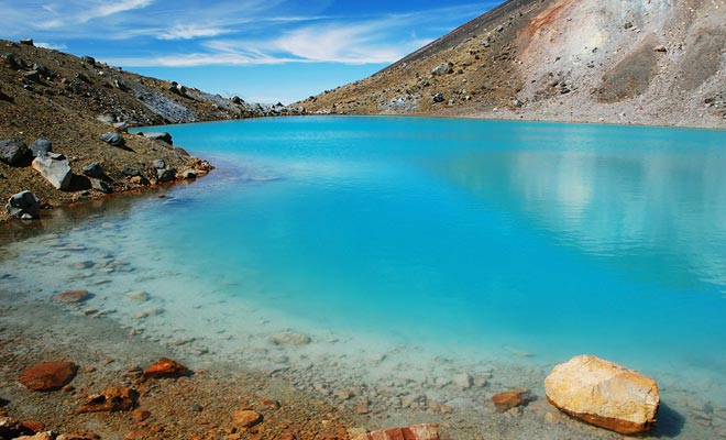
The turquoise lakes are of volcanic origin.
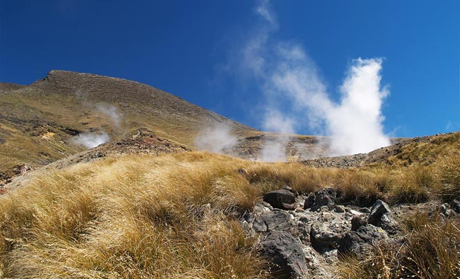
We are at the extremity of the Pacific Ring of Fire. The trek crosses land where volcanoes are still active. Of course, activity does not mean they are erupting with lava flows. You are not going to die here, this is not a dangerous place, but these volcanoes awake many times each century and are constantly monitored by experts.
Of course, exploring a volcanic land is an activity you should prepare seriously. One just cannot afford to come with hands in the pockets. There is a minimum of precautions to observe for such a trip and a minimum of organization.
Each year, nearly 100,000 hikers follow this great walk. The total distance is about 19.4 km and most people will be able to do it in just one day.. If you are reasonably fit, it will take an average of seven hours to complete the full path!
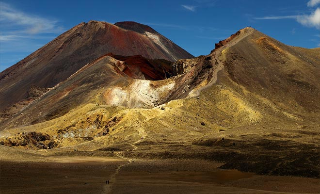
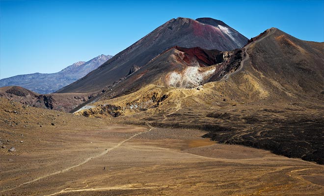
With 19.4 km to go, it takes a minimum of fitness.
All these remarks are not intended to discourage you! The Tongariro Crossing is a must-do of New Zealand, and anyone in good physical condition should do it once in his life. The breathtaking beauty of the Tongariro should be enough to motivate most of you.
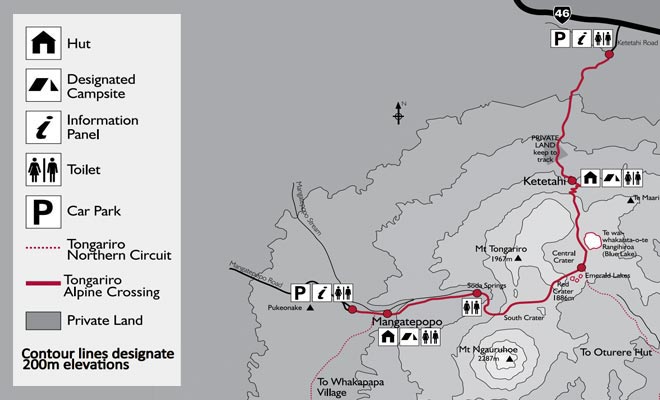
The route from the Mangatepopo car park to Ketetahi.
I myself will guide you and present all the challenges and difficulties you can expect on your way.
At the very end of this guide I will also introduce you Ben the Kiwi, our best expert of the Tongariro who will address the more technical issues and answer to your questions.
It will be a great opportunity to review the equipment issues, the safety rules, the weather conditions,, or the required fitness. After reading this article and with the advices of Ben, you'll be ready for the Tongariro Crossing.
Meet me at the departure point of the trek for an incredible adventure in New Zealand!

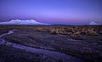
The vegetation will gradually disappear.
Usually, the trek is to be done between late October and May. Outside this period, access is always open, but may require the help of a mountain guide.
Each season has its advantages and disadvantages. But I recommend to plan your trek during summer time and to start early in the morning.
The starting point is at the Mangatepopo car park and the final goal is on the opposite side of the Tongariro. The itinerary could be done in reverse direction, but it would imply add an extra hour of walk (trust me, I have done it). We'll follow the classic itinerary today, because we must not miss our return shuttle at the end of the track.
Our first step consists to reach Soda Springs. We will follow a rocky path along a stream. Wooden planks facilitate walking during this part which is just a kind of easy warm-up for the muscles.
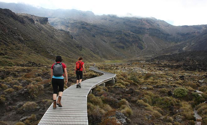
This part is easy and should not be a problem.
Discover the trek with a Kiwi guide.
Filmed by barekiwi.The eastern flanks of the volcano being exposed to low temperatures, dry vegetation is limited to heather and tussock (a variety of bunch grass that grows on wet soils).
We will cross a bridge about twenty minutes from the start. Mangatepopo Hut has dry toilets, but does not provide drinking water. By the way, remember that you will never have the opportunity to fill your water bottle during the entire trip! A whole section of Ben's advices is also dedicated to the equipment and provisions to put in your backpack.
Thereafter, the path will climb gently to reach Soda Springs. The gradual disappearance of plants announces a change of relief. We are passing through ancient rivers of lava solidified. The recent flows can be easily distinguished by their dark colors and the total absence of vegetation.
Welcome to the Mordor!
At dawn, you're likely to walk in a light fog. Surrounded by all these strange volcanic rocks, you will understand the choice of the New Zealand film director Peter Jackson.
This dark area was chosen to represent the Mordor in the Lord of the Rings trilogy.
We are approaching Soda Springs with a complete change of scenery. The higher we climb the more the panorama reveals the extent of the lava fields.
This is an opportunity to take some pictures and nibbles some energy bars before proceeding to the toughest part of the Tongariro.
Soda Springs marks the beginning of the ascent to the crater.
We are at Soda Springs, our first stop of the day. A signpost announces several directions. A path leads to sources with high carbon dioxide levels, an oasis where grow ranunculus and beautiful digital. If you have won some time by walking faster than expected, I recommend this little detour.
Another trail leads to an alternative trek towards Mount Ngauruhoe.
For four hours' round trip, this additional itinerary escalates the volcano and is not suitable for beginners. We'll discuss it another time if you don't mind.
The Ngauruhoe is a complex volcano, with many craters carved by ancient glaciers and eruptions.
One must realize that 18 meters' deep lava rivers were flowing here! One year after the last eruption, a hand contact with the solidified lava was still hot.

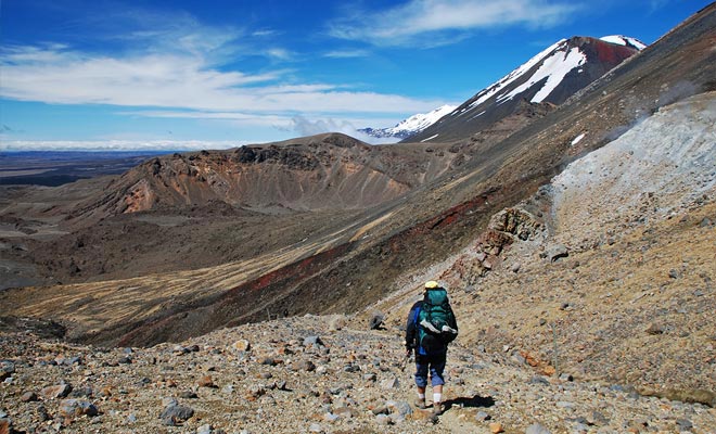
This phase of ascension in single file is the most trying.
Keep your calm, if there was a risk of eruption, access to trek would have been closed. Volcanic activity is monitored 24/24 h and this kind of lava is known to be extremely slow.
Pardon me to address the issue, but the toilets installed in Soda Springs are the last you will see for at least four hours... Please take your time to regain some strenght, because we are now ready to climb towards the south crater.
Devil's staircase deserves its name, you'll need breaks.
The ascent takes place at the junction between the mounts Tongariro and Ngauruhoe.
This is the easiest way yet it is called Devil's Staircase. After all, we are in the Mordor of The Lord of the Rings!
From a security point of view, there is no reason to be afraid with this part. Just watch your steps and take your time.
You will have recognized the Mordor from The Lord of the Rings.
The ground is covered with rocks of a few centimeters known as slags. They are spewed by the volcano when it is angry. The key is to move forward calmly, taking the time to make small breaks to catch your breath.
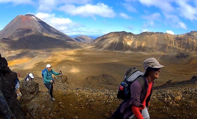
Most people will agree to say that this part is the most tiring of the entire Tongariro Crossing. Fortunately, the unobstructed view on the ancient lava fields justifies your efforts.
In the distance, you can see mount Taranaki that resembles Mount Fuji (a trick used for “The Last Samurai” with Tom Cruise). The smoke that escapes from the distant crater seems to convey a message.
The landscape rewards greatly the efforts made.
Maori legend says that at the dawn of time, four volcanoes warriors occupied the region. They fought to win the affection of Ruapehu, a beautiful mountain. In a flood of flames, Mount the Tongariro defeated his opponents. One of them, the Mount Taranaki has sought refuge 180 km west, destroying everything in its path.
Since then, volcanoes continue to defy each other. They growl and sometimes erupt to mark their hostility. The Maori warriors have long considered the smoke of volcanoes as signs of a coming war.
After 400 meters of effort we will finally set foot on the flat ground of the south crater. If you take your time to breathe deeply, you should be able to recover in no time.
We are approaching one of the most memorable moments of the hike and of your entire trip to New Zealand.
The south crater offers an extraordinary panorama.
The south crater occupies a large space between two volcanoes. On the left, the jagged ridge belongs to the the Tongariro. On the right, Ngauruhoe is distinguished by its cone with red borders.
If it has rained the day before, the ground can be a little difficult. The soil consists mainly of sand and rocks. In fact, it is not a crater but an old basin dug by a glacier.
The rocks were deposited by volcanic eruptions. Depending on the season you may find some remaining ice layers, so be careful.
We will resume our climb. The bad news is that the ascension extends over 300 meters and is a little grueling. The good news is that we are on the last real climbing part of the trek. Once this is done, the rest of the trip will be done on level ground or downhill most of the time.
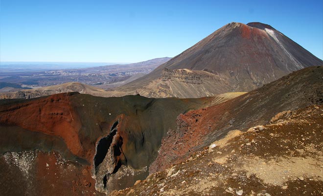
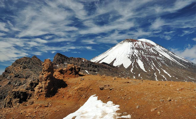
The red crater draws its color from the oxide of iron.
The east wind will be your main opponent during the climb. If you bothered to cover you well, this should not discourage you.
Follow the path marked out by the signposts and you will soon pass this difficulty.
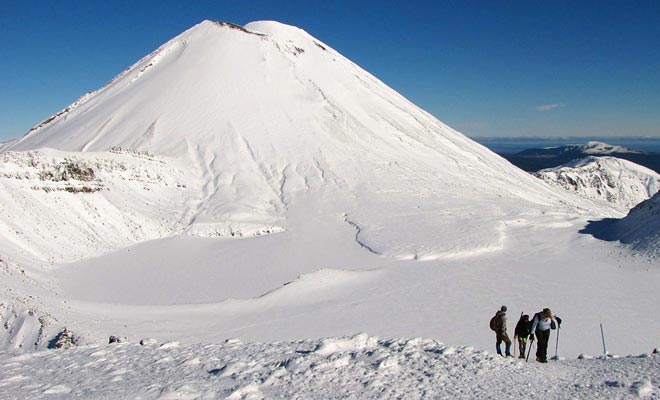
A few moments before reaching the top, you will notice that the path divides in two branches. There is another hike of 2 hours (round trip) which allows to climb the Mount Tongariro. We will focus on our itinerary, but Ben the Kiwi will give more details about this secondary hike later.

Be careful not to fall, keep your distances.
Congratulations, you've reached the culmination of the Tongariro Crossing at a 1886 meters’ altitude.
Go to the right to admire the red crater of Mount Ngauruhoe. Its bright color comes from the oxidized iron present in the rock. Have you ever seen such a sight?
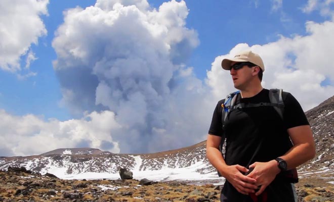
Some smoke occasionally escapes the gaping crater. A sulfur smell reminds that this young volcano (5,000 years old only) is still active. Its last major eruption was in 1954 and lasted for almost a year. The most recent in August 2012 caused the temporary closure of the trek.
This report explain the latest eruption.
Tolkien's fans will recognize the mountain of fate (Orodruin) from The Lord of the Rings.
This is where Frodo and Sam are venturing to destroy the One Ring of Sauron with the unintentional help of Gollum. However, Peter Jackson's teams were not allowed to film the volcano's crater because it is considered as a sacred place by the Maoris.
According to a legend, the great Ngatoroirangi wanted to rule this region. An ambition also shared by his rival named Hapekituarangi.
Both sorcerers came to an agreement and decided that the region should belong to the only one who could contemplate it entirely. Ngatoroirangi began to climb the Tongariro before his opponent. In order not to succumb to the cold wind that paralyzed its members, the sorcerer summoned the sacred fire from the bowels of the Earth.
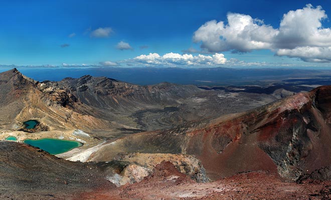
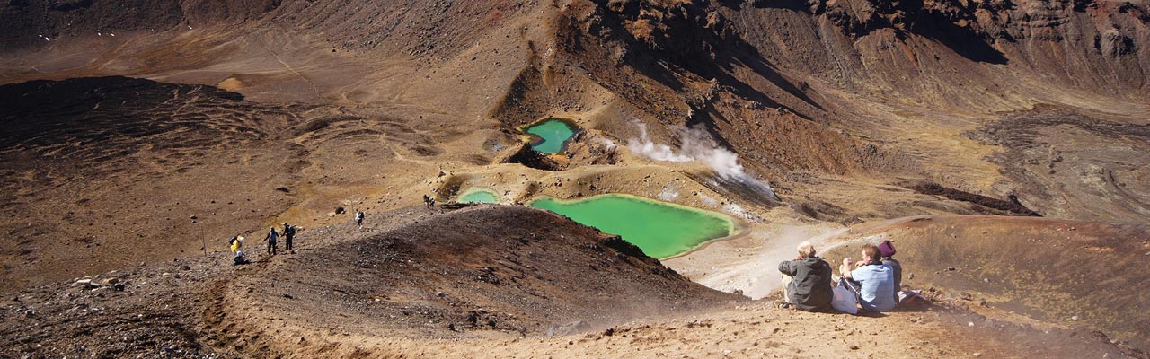
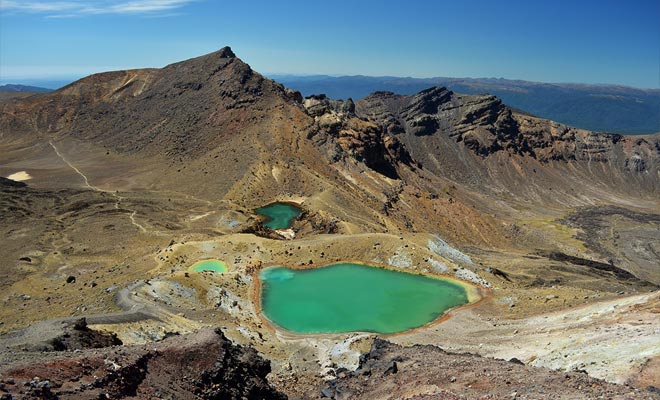
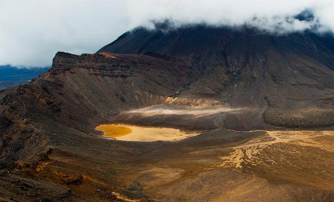
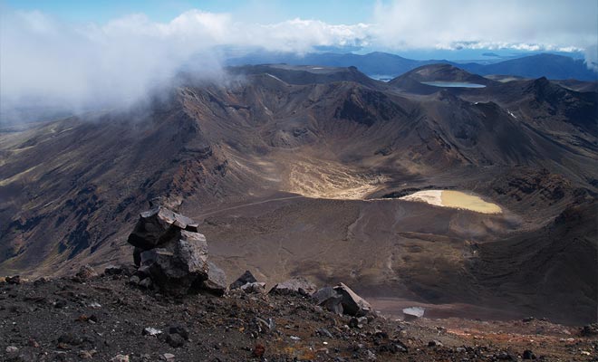
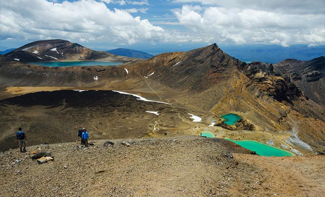
We are at the halfway point, the turquoise lakes are the key attraction.
Keep a safe distance with the edge of the crater and admire the breathtaking views all around you. The Rangipo desert that extends far away is impressive. The red crater of the Ngauruhoe looks like a Martian landscape. But the discovery of the emerald lakes of the central crater will be the great reward for all your efforts.
Here is the descent to be accomplished on the slope of the volcano.
The descent to the lakes takes place on a steep mountain's side. Even if you do not have vertigo, there are reasons to be concerned. On the map the distance is short and can be covered in fifteen minutes. But if you feel a bit scared, and if the wind blows, it will take twice more time to succeed.
One must beware of the volcanic slags, because these rocks sometimes slip under the feet. Remember to warn people who are walking in front of you if you dislodge a big rock.
Remember to look occasionally behind you for not staying in the axis of another hiker. I think I can guess what you're thinking ...
I'm subject to vertigo, and on my first visit, I confess I was a bit nervous…

The important thing is to take your time not to stress yourself.
In a condition of stress, many people stiffen, which is alas the best way to facilitate the falls.
You should relax, because you aren't going to descend the slope like a snowball. There are too many asperities for that to be possible.
And if you had the great idea to take trekking poles with you, this part will be far more easy and fast than what you could imagine.
Even without this equipment, and if you take your time (nobody is judging you), this is far more easy than it seems.
Turquoise lakes sometimes release sulfur vapor.
The emerald lakes are named Ngarotopounamu, a maori name meaning “pounamu lakes”. The pounamu being a stone that resembles jade. You will find many of these stones in most souvenir shops of the country. Three lakes can be observed: one large and two small. Their particular shade is related to mineral acids. When it's cold enough, the lakes can produce steam and a smell of sulfur. I should point out that these wonders may be hidden under ice during winter: It's a bit disappointing, but the spectacle of the snowy crater compensate for their absence.
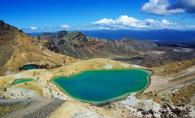
It goes without saying that turquoise lake water is not drinkable ...
There is no need to say that the lake water is not drinkable and this is the worst place in the world for swimming.
You have plenty of choice to find a large rock to sit and picnic.
You can consider that the difficult part of the hike is over. This does not mean there's nothing to see after, on the contrary. We are only halfway and if you knew what awaits us beyond the central crater ...
The walk in the central crater presents no difficulty.
Crossing the central crater takes about twenty minutes. It's a pleasure, even in winter when the ground is covered with snow. A desert landscape, lunar, which covers one square kilometer. The soil consists of several layers of solidified lava.
The ascension to leave the crater will be brief. Before continuing, take a last look behind you. The tiny dots that move in the distance are not ants. These are the latest newcomers who begin the great descent that we borrowed. This should give you an idea of the scale!
The blue lake discovered in 1750 is sacred to the Maoris.
On the other side of the crater, you will discover a beautiful blue lake. His real name is Te Wai-whakaata-o-te-Rangihiroa, “Rangihiroa's mirror”. Discovered in 1750 by a Maori explorer, this lake is sacred (tapu) and it is forbidden to eat or drink nearby.
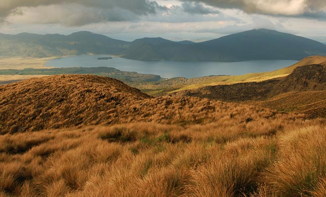
The spectacular view of Lake Rotoaira.
After walking along the shore of the lake, the path continues on the side of the crater. We'll reach soon the other face of the mountain.
What a sight! Lake Rotorua and Mount Pihanga offer a breathtaking panorama!
Further north, Lake Taupo occupies the caldera of an ancient supervolcano. Its latest explosion has changed the face of the world and covered with ash much of the country. If the subject interests you, you should read my other article about the Huka Falls.
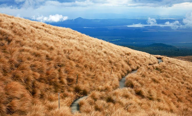
The descent to Ketetahi Hut in the middle of the tussock.
The descent takes place sheltered from the wind. The foam and bushes begin to reappear. Finally, tussocks cover the floor and the temperature rises again.
The itinerary continues in zigzag up to Ketetahi Hut, an alpine shelter originally built for hikers of the Tongariro Track (a 3-day walk in the region).
All the rest of the path will be downhill!
The last eruption of Ngauruhoe projected firebombs at several kilometers! Some fell on the refuge. This explains the prohibition to occupy this place to spend the night. Anyway, it was not our intention. We will merely use the toilet and the benches to have a rest.
You should start to feel the the burden of fatigue. But there is no reason to speed up, especially if you are ahead of the shuttle timing. Stay as long as you can to enjoy the view. Once you have regained strength, you can finish the trek easily.
Stay on the trail, because some Maori lands are sacred.
The descent on a slope covered with bushes shaken by the wind is one of my favorite parts of the Tongariro Crossing. After twenty minutes, you will see white smoke emanating from the hot pools of Ketetahi Springs.
This land belongs to Maori tribes Ngati Hikairo and Ngati Tuwharetoa. A holy ground that we're not allowed to cross and even less to photograph.
The Maoris have a close relationship with nature. The Tongariro was given to the New Zealand government for he ensures the preservation of this sacred heritage.
Volutes rise from hot springs of Ketetahi Springs.

A superb timelapse on the volcanic crater of Te Maari.
Directed by Bevan Percival.You will have to content yourself to stay on the path, but do not be too disappointed. You can observe the bright yellow sulfur rocks.
The last eruption of 2012 somehow “embellished” le paysage. Tons of fresh ash fell on the region like snow. Thousands of projectiles were propelled at over a kilometer where they dug craters. And a new lake was even formed!
The damage caused by a lahar are particularly apparent. This term refers to a torrent of mud and rocks rolling down the slopes of a volcano. The phenomenon is as impressive as destructive.
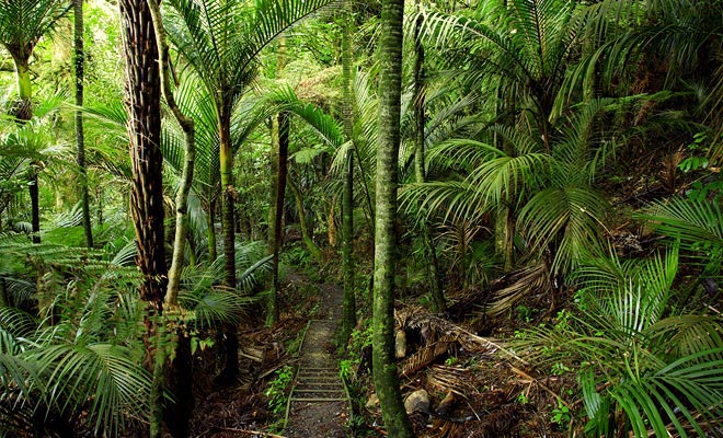
The virgin forest brings shade and freshness at last.
The vegetation will become increasingly high until we reach the bush.
The pristine forest, an oasis of greenery and freshness is a blessing. After the lunar landscape of volcanoes, the contrast is striking. Fortunately, the forest has been untouched by the last eruption of Ngauruhoe.
Journey's end often takes place on planks and a few stairs facilitate the descent.
We follow the course of the Mangatetipua Stream, which litteraly means “the enchanted river”. Do not let the name mislead you: the water is not drinkable, contaminated by minerals from the close volcanoes.

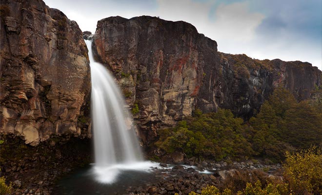
A small detour allows to admire a beautiful waterfall.
There remains just half an hour of peaceful walk listening to the sounds of the forest and the sound of the stream.
I would recommend you to take your time, but at this point of the day, you are probably exhausted and you just want to finish the trek to have a rest.
If you still have some energy, I just want you to know that a small detour of a few minutes allows to reach a beautiful waterfall.
The arrival when you complete the Tongariro Crossing.
What more can be said? You have reached the Ketetahi car park. All you have to do is to wait for the return shuttle, sitting on a bench or lying in the grass. You finally defeated the the Tongariro Crossing, walk through an incredible variety of scenery all day long. Now you can select the photos of the trek to impress your friends!

The sun sets over the Tongariro National Park.
You can imagine the pleasure to go to dinner with friends after such a day. As for me, a fine wine bottle and a huge pizza will do. If your hotel has a spa, you will hardly leave it.
Let's consider the trip we made for a moment. If you add up my time estimations, you will get a total of about 6 hours. Only good walkers who make very short breaks can keep this pace.
For the others (in other words almost everyone), it will take one or two hours more on average. No big deal, you should keep an eye on your watch.
If you have achieved a stage of the circuit within the allotted time, you can automatically grant yourself a fifteen minutes' break (or even more, depending of the shuttle planned at the end).
Don't rush, because a classic mistake is to chain the steps between Devil's Staircase and the red crater without having a break.
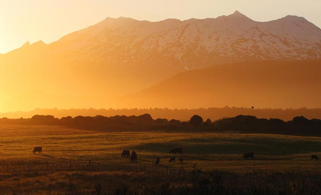
If you are still awake, come to admire the sunset.
As I promised you, you'll meet Ben that will answer all your questions. For once, the reading of Ben's practical advice at the end of the article is not optional.
If you intend to do Tongariro Alpine Crossing, you should read all his advice. Before leaving you with him, there are just few additional points I would like to address.
For your convenience, I insist that you use trekking poles (rentals possible in Ohakune or Taupo for $10). I can assure you that during the descent between the red crater and the emerald lakes they will make all the difference and spare your knees.
Walking sticks are not accessories dedicated to seniors, even the best backpackers use them for mountain treks.
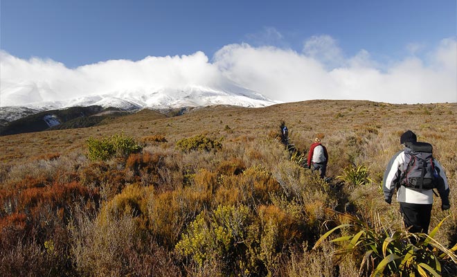
The crossing in winter requires the presence of a guide.
A timelapse on the Tongariro National Park.
A creation by Bevan Percival.I consider the Tongariro Crossing is a trek that can be followed by teenagers and seniors as well. Those who have had the chance to live this adventure will all tell you the same thing: “It was tiring but amazing all along”.
Alas, there is a tiny minority usually coming with hands in pockets, without equipment, without provisions and without monitoring the weather before the departure. Kiwipal has a duty to warn these people of the danger.
Please consider the safety issues seriously, and nothing will spoil your fun. Then, the pride of having overcome all the difficulties will remain in your memory for the rest of your existence. But if you have doubts about your ability to do this trek, why not ask the advice of a professional guide?
There are other exciting treks in this area.
You know, Kiwipal works hard to help you make the most of your stay in New Zealand. Nothing makes us happier than receiving your travel photos.
Once you have striped the Tongariro line from your to-do list, please remember to send us proof of your achievement. The trek evolves over time, and if you have noticed some changes, please let us know.
The Tongariro National Park is not so far from the Huka Falls, the geysers of Rotorua or even Hot Water Beach. New destinations that we will be pleased to share with you! I say no more and I give way to Ben for his practical advices.


What can I do for you? I have grouped the most frequent questions on the Trek. Keep in mind that I am not a doctor! I cannot give advice about health conditions! Please consult your doctor if you have any doubts about your physical abilities.
No, the point of departure and the point of arrival are at two different places. You have to organize your transportation by booking a seat in a shuttle. You can also get to the parking all alone if someone drops you off and comes get you up for the return trip.
You must reach the Mangatepopo Valley. A junction is indicated along State Highway 47. Follow Mangatepopo Road to the car park where the trek begins.
The Ketetahi car park is accessible via the SH46 on Ketetahi Road.
There have been car stealing in the past. Do not leave anything visible inside the vehicle and carry no valuables.
No, but mobile phones work pretty well in this part of New Zealand.
Please contact the i-Site or ask to your hotel. Departures are possible from Taupo, Turangi, Whakapapa, National Park and Ohakune. Often, private shuttles provide transit from your hotel.
Depending on the distance, it usually takes from $25 to $35 for a trip.
You can check the website of this company:Extreme Backpackers
Check out these two websites:Tongariro Crossing GuidesAdrift
Bicycles are prohibited in the Tongariro National Park.
There are three basic toilets often stormed. One cabin is located at Mangatepopo Hut, another at Soda Spring and the last at Ketetahi Hut on the other side. If you are a man, you can always improvise a toilet behind a rock. Since there are often many people on the track, it will not be very convenient, but for the ladies, it will be even less practical. The open field and the absence of bushes does not facilitate the thing ...
You have to be thin and fit. If you do not practice any sport including walking, I do not recommend you to start with the Tongariro unless you are young enough. Otherwise, you go to drag aches for several days. The climbs and descents put the knees to the test. You can remedy this in part with walking sticks.
I saw younger, but in my opinion, one must be at least 12 years old. The Tongariro Alpine Crossing is not the ideal hike to realize that your child is suffering from vertigo. You must know their limits and frame them. Why not consider booking a tour with a guide? It is a long walk for children. The strong wind is likely to fatigue them faster than you.
Yes, if you know your limits well and have tried long walks to test you.
By taking breaks regularly. It is always tempting to follow those who go faster. But we are not in a race. Take time to take regular breaks to drink and eat. You must warm up your muscles in the morning before leaving, and start to walk slowly.
If you are no longer young, this is actually desirable, unless contraindicated.
If you have a moderate vertigo that does not paralyze you, it is quite possible. It is impossible to answer for you about such a personal problem. Watch videos of the trek on Youtube to make yourself an idea. You can also ask the advice of a guide in an i-Site in town.
Yes, the itinerary is a little more physical, because you advance in the snow and on ice.
Yes, but going downhill will be a bit complicated if there are people (which is almost always the case).
Of course not ! The estimated time take into account the necessary breaks.
Here is the ideal outfit to face the Tongariro in the best conditions (and you will have other opportunities to use this equipment during your trip to New Zealand).
3 layers of warm clothing. Wool or fleece, but no cotton please! (It dries too slowly.) Depending on the temperature, you will add or remove thicknesses. The first layer must be impermeable (k-way or waxed). Try to find the lightest clothing possible.
Waterproof pants. Avoid jeans because they take a long time to dry after the rain. The shorts are to be proscribed including in summer.
Hiking shoes (which you obviously do not wear for the first time!).
A pair of walking socks to avoid the blisters (consider taking dressings).
A hat that covers the ears well (possibly a hat, but the wind has a good chance of snatching it).
A pair of gloves, sunglasses, sunscreen, toilet paper.
A backpack for storing supplies and the two layers of clothing that you will often remove or put back.
Walking or skiing poles are not essential, but highly recommended.
A towel (you never know).
The drivers of the shuttles are instructed to refuse to take you on board if you do not seem properly equipped. One does not joke with your safety.
You will often add or remove your anorak. Another reason not to overload your backpack. The main thing is to have a minimum of two liters of water per person. As for food, it is necessary to eat foods high in energy. Some cereal bars and some dry fruits accompanied by a good sandwich will do the trick. Be careful not to overeat or it will make the walk more difficult. Of course, do not leave any dirty papers behind you!
Two precious tips: Rent walking sticks and take a plastic bag so you can sit dry on wet rocks.
The hike starts early in the morning and it is cool in the desert. After an hour of walking, you will get hot and you will be furious after me for having given such advice to cover well. But as soon as you go to attack the ascent part, the cold wind will blow and you will be glad to have followed my advice. The weather is very unstable and it can rain even if the weather looks fine.
There is not a single water point during the entire hike. The water in the lakes is not drinkable even with a filter. You will be spending a lot of energy and you will have to compensate to avoid dehydration. A liter and a half may suffice, but that is the bare minimum. Last detail, there is no coffee on the departure or arrival. Take into account the travel time!
Yes, the basic hiking shoes are not good enough because you will often walk on ice. Most guides will provide you with crampons to fix on your boots.
Your sports salesman will advise you better than I do. There will be a lot of descent to do, so do not touch the tip of the shoe with the toes.
Formerly, the hike was just called Tongariro Crossing. It has been renamed into Tongariro Alpine Crossing to insist that it is a mountain trek. The trek in itself is not dangerous: the Tongariro would not attract 100,000 travelers each year if that were the case. The danger, if it exists, almost always results from a lack of preparation. If you take the time to read my advice, everything will be fine.
In summer you can do the trek without a guide. But nothing prohibits you from renting the services of a mountain guide. In winter, that's another story. Unless you are particularly experienced, the presence of a guide is essential. You will often need to use an ice ax and crampons are required.
The quality of reception is quite variable according to the operators. This is why a person outside the hike must be aware of your plans. If you use the services of a shuttle, you will be given a number to contact in case of emergency.
As elsewhere in New Zealand, you can call the 111 on a cell phone (if you're in a coverage area). If you are immobilized, try to stay warm and calm while waiting for help. Usually, it is a helicopter with rescuers who will pick you up. By observing your absence, the driver of the shuttle will give the alarm. If you wish to come by your own means, you should imperatively signal your intention to someone before starting the hike:Outdoors Intentions
The track is very well marked, but I advise printing a map of Tongariro Crossing from this site:Tongariro Alpine Crossing itinerary
If you have booked a shuttle, you must inform the driver. Otherwise rescuers will be sent to find you. If you want to travel on your own, check out this service:Outdoors Intentions
To prevent searches from being triggered if you do not answer the call. If you are late, you must inform the driver of the shuttle. The schedules were calculated to leave you a good margin to complete the circuit. In winter the days are shorter and must be taken into account (a guide will manage this parameter for you).
Clear and sunny weather ideally. But rain is tolerable if it is only transitory. At high altitude, it can very well snow. I recommend not to tempt the devil. If you have the opportunity to wait for several days during your stay, wait for the good weather. Otherwise, do not be afraid to give up. Also watch for sundown schedules, especially in winter when the days are shorter.
Starting the trek early in the morning and under the rain is the perfect way to undermine your strength and motivation. I consider that it is a course to be carried out in good weather at least during the first part.
The answer is very clear: NO!
Because the reliefs of the volcanoes are the only ones to retain the clouds and we are not very far from the sea.
On this page :Tongariro Alpine Crossing Weather
The winter period extends from the 1st of June to October 31 in New Zealand. You will find snow and ice on most of the itinerary. The high season runs from November 1st to June 30, but there may still be some snow at altitude.
During the high season, the Tongariro often hosts more than 1000 visitors each day. This influx is a little embarrassing during the first part of the hike. The ascent takes place in single file. When you reach the central crater and the emerald lakes, there will be more space to circulate.
In summer, this is quite difficult if you come on site with the shuttle. Try if possible to come during the week (there are about 10% fewer visitors). A more radical, but unguaranteed, solution is to come much earlier (5:30 am) or later (around 11:00 am). In both cases, you will have to manage the transport yourself. This is not obvious, because this implies that a vehicle drops you off, and pick you up at the end.
This is a bad idea for two reasons. The first part of the trek will be a long ascension. The second is that you will constantly have to avoid the other hikers who come in reverse. As the trails can be a little narrow, you will constantly have to give way.
Yes, insofar as the course takes place in the snow and requires the presence of a guide.
It is not always easy to combine physical effort and politeness. But try to respect the minimum rules of the good hiker: to keep the smile and to let pass those doubling. But the atmosphere is generally excellent.
There is always a chance that an eruption will occur despite the predictions of vulcanologists. However, such eruptions are rare, as volcanoes give many warning signs in the weeks before they awaken.
From the parking lot you will be informed by a sign. The information is also available more simply on this site:Tongariro weather
It dates from August 6, 2012, and the eruption has evacuated the pressure of the volcano. The trek was reopened to the public in November 2012.
The Maori legend says that a young slave was sacrificed at the top of this volcano by the sorcerer Ngatoroirangi. The start of the itinerary is at the level of Soda Spring. You will have to climb near the scree along the rocky crest. The path leading to the crater is not marked. Upon arrival, a fantastic view of the valley and the desert of Rangipo awaits you. Count about 1h30 to 2h for the climb and 30 minutes to go down. It is a difficult hike and the slope covered with slag can afraid the beginners. If you have dizziness, you may pass your turn.
It is the smallest of the three volcanoes in the region. It takes 1h30 to 2h round trip for this complementary excursion. The starting point of the circuit is just before the red crater of the Tongariro. The path is marked by poles. It is a track that climbs, but remains accessible to beginners if they are very motivated. The view is superb. In winter, you must be equipped with crampons to avoid slipping, and you must be accompanied by a guide.

Many people exaggerate or underestimate the difficulty of Tongariro Crossing.
With experience, I consider it a reasonable Trek if the weather is nice, and difficult when it rains and if the track disappear in the fog.
I discovered New Zealand in 1997, and since then, I share since my experience on Kiwipal with other fans of the country.
Our mission is to guide you off the beaten track with our tailor-made trips.
The Tongariro Crossing is located in the Hawke's Bay region of ??the North Island.